
What was it?
In 1909 the Chancellor of the Exchequer gave the traditional budget speech outlining his plans to deal with the nation’s finances for the coming year. The measures he outlined where then presented for parliamentary approval in the customary Finance Act of that year (10 EdVII c.8). In his speech the Chancellor of the day, David Lloyd George, proposed a new tax to be levied on the gain in value of land. This tax was to be calculated as a proportion of the rise in value of land and would be paid whenever the land changed hands through sale, inheritance, gift or the grant of a new lease.
The tax was not on the total value of the property, only on the land so the value of buildings, businesses, rights etc. was not taxed.
In order to levy such a tax the first step is to determine a value for the land at the time the Act came into law. This could have been done when the property changed hands as a retrospective calculation, but this was not the approach adopted. The method chosen was to value every property in the country to provide the baseline value against which the tax would be levied in the future.
The process became known, officially, as the Valuation Survey and, unofficially, as Lloyd George’s Domesday. The survey was not limited to houses or buildings, any land was subject to the new tax; fields, gardens, allotments as well as waterways etc. were assessed.
The Records
The records of the Valuation Survey for England & Wales are held in the National Archives (TNA) and in local county record offices. Holdings vary; this article now focuses on the surviving records for Berkshire, in particular my own area of interest – Newbury.
TNA and the Berkshire Record Office hold similar but different records. The records held by TNA are those returned to the Inland Revenue as the end result of the Survey, those in the BRO are working documents that were kept locally by the valuation officers. The key to finding a property is to use one of the maps generated during the survey. These are standard Ordnance Survey maps of the time, dated around 1910. The Survey took some time to complete so maps dated 1911 are not uncommon. Each map is annotated to define properties being valued. The maps at TNA (IR 121-125) are complete and identify almost every property by colour shading to differentiate it from its neighbours and by the addition of a number. This number references an entry for that property in the Valuation Books (IR 58). The maps at the BRO (D/PVO3) may be incomplete with a few or many properties yet to be highlighted. In this case it may be necessary to extrapolate from numbers on the map to guess what the property’s number may be. Again these numbers reference the Valuation Books, both at TNA and at the BRO (D/PVO6).
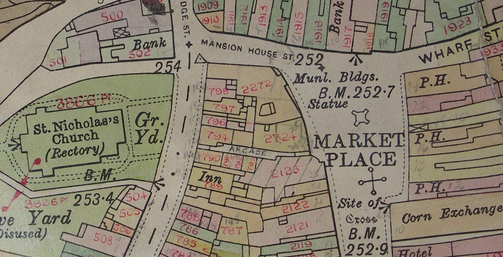
Maps are wonderful and this survey can be extremely useful in determining the extent of a property but family historians will probably want to investigate the Valuation Books as soon as possible.
The Valuation Books held by the BRO and TNA are radically different. Both contain the same basic information about each property – its location/address, occupier, owner, total value, value of assets on it (buildings etc) and its assessable value. However the presentation is totally different and each has information that the other does not – for the most complete picture both should be consulted.
The books at the BRO covering Newbury do so in three volumes with each of its 3936 properties detailed in a line across a double page spread of 40 columns. At TNA the books are much smaller but devote two double page spreads to each property; Newbury is covered in 40 of these books.
At BRO there is more information on the people, full names are given that are often abbreviated at TNA. So Harriet Maria Bailey renting a cottage in Waldegrave Place is show as H M Bailey while her landlord is shown as Paulin, George, Star Inn, London Road in the BRO and Geo Paulin at TNA. This difference is the norm for Newbury.
However, TNA has the advantage when it comes to the property as some (sadly not the majority) have quite detailed descriptions of the property; so we find that 1 Burton Terrace, Russell Road is a B & T [brick& tile ] End terrace house, G Fl [ground floor] Sitting room, Kitchen, Scullery, Pantry, Coals & W C. 1st Fl 3 Bedrooms. Where a property described in such detail has been demolished or radically converted the information is more valuable, I wonder how recognisable this would be to the staff of the TUI travel agents at 91 Northbrook St (inspected 20 Mar 1911): Frontage to W side Northbrook St 28’ 6” Accommodation Ground Floor Shop about 24ft x 18ft Sitting Room, Side Entrance & lobby, Kitchen, Scullery, Small larder. On 2 upper floors 6 bedrooms, 4 with fireplaces & box room. In yard 2 WCs and coal house at end of long passage small garden. Premises formerly part of adjoining house old but well built & in fair structural repair. Decorative repair bad, boundary walls bad.
There are also details of any covenants having a bearing on the property. At 4 Northbrook Street was the ironmonger’s business of N M Toomer which has the following covenant By the Will of N M Toomer it is devised to the life tenant for her life subject to the personal use and employment thereof by the said Frederick Arthur Greet [occupier] at a fair annual rent to be paid by him to the said Fanny Ella Greet [owner]. We also find that there is a right of way over the yard to & from the Presbyterian Meeting House. In his will Neville Toomer looked after the interests of his daughter (Fanny) while effectively passing the business on to his grandson (Arthur Greet).
Wherever your ancestor lived in 1910 or thereabouts there is a good chance that the head of the household will appear in these books. However, as is typical with property records it is the poor that are least likely to appear; buildings with multiple tenants are unlikely to provide details of every tenant. If you have a property owner in your family tree you can certainly get a good picture of their holdings from this survey; some areas, especially in the recently built streets on the old West and East Fields there are rows of houses owned by the same landlord – ‘buy to let’ was as popular an investment as it is 100 years later.
Far more detailed than the 1087 Domesday the Lloyd George version is an outstanding resource for local history and gives family historians a rare chance to look into the way their ancestors lived 100 years ago. However, the tax was not a success and was abolished after only 10 years, many must have thought the expense and effort that went into the Valuation Survey was largely wasted – historians with any interest in the period would certainly disagree.
The Newbury Survey
Below is an index to books held at TNA (IR58 69057-69096) covering the survey of all of Berkshire. The boundaries of the town have expanded since this survey, most notably the area of the town to the east of Boundary Road. Any such area would be included in the survey books of the civil parish they were then a part of – and not in this index.